檔案:Old South Jacksonville City Hall.jpeg
跳至導覽
跳至搜尋


預覽大小:800 × 450 像素。 其他解析度:320 × 180 像素 | 640 × 360 像素 | 1,024 × 576 像素 | 1,280 × 720 像素 | 4,160 × 2,340 像素。
原始檔案 (4,160 × 2,340 像素,檔案大小:3.69 MB,MIME 類型:image/jpeg)
摘要
| 描述 |
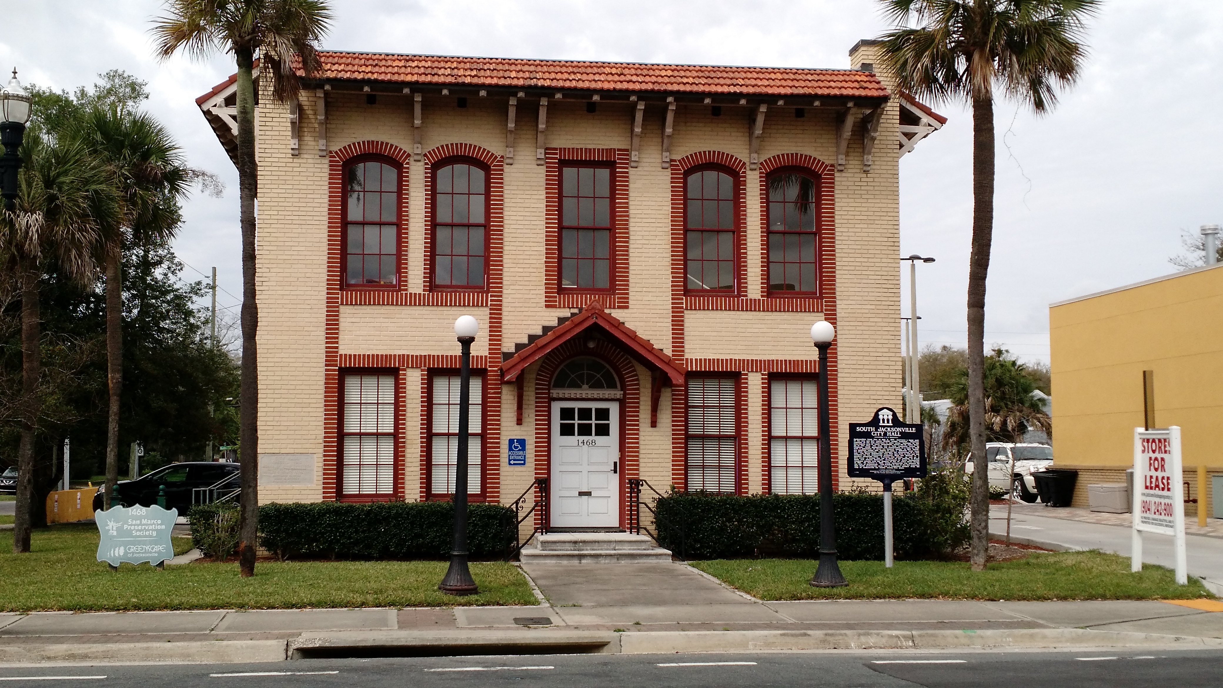
English: Sign reads: Jacksonville's Great Fire of May 3, 1901, destroyed a large part of the city and left nearly 10,000 people homeless. Numerous residents of the city relocated to other areas, including to the then-remote area of South Jacksonville, across the St. John's River. Up to this time, this area was a farm community known as Oklahoma. South Jacksonville was incorporated as a town in 1907 with a population of about six hundred people. In 1913, ninety-six qualified voters cast ballots to pass a $65,000 bond issue Cor civic improvements, which included the construction of a city hall. The South Jacksonville City Hall was built in 1915 and was designed by the Jacksonville architects Mark and Sheftall in a masonry vernacular style. It housed city offices, as well as a fire truck. A trolley line ran in front of the building to Beach Road, now Atlantic Boulevard. Development in South Jacksonville expanded greatly with the opening of the St. John's River Bridge in 1921. On January 1, 1932, South Jacksonville was annexed by the City of Jacksonville. This building is one of the few reminders that South Jacksonville once was a community distinct from the City of Jacksonville for nearly twenty-five years.
Español: El Gran fuego de Jacksonville, 3 mayo, 1901, destruyó una gran parte de la ciudad y dejó cerca de 10.000 sin hogar. Numerosos vecinos de la ciudad reubicados a otras áreas, incluyendo a la zona de sur de Jacksonville, a través del Río St. John. Hasta aquella momento, la área era una comunidad agrícola conocido como Oklahoma. South Jacksonville fue incorporada como ciudad en 1907 con una población de alrededor de seiscientas personas. En 1913, noventa y seis votantes calificados votaron para aprobar una emisión de bonos de $65.000 por mejoras cívicas, que incluía la construcción de un ayuntamiento. El ayuntamiento de South Jacksonville fue construido en 1915 y fue diseñado por arquitectos Mark y Sheftall, de Jacksonville, en un estilo mampostería vernáculo. El ayuntamiento albergaba oficinas de la ciudad, así como un camión de bomberos. Una línea de tranvías corrió delante del edificio a Beach Road, ahora Atlantic Boulevard. El desarrollo en South Jacksonville ampliado en gran medida con la apertura del Puente de Río St. John en 1921. El 1 enero, 1932, South Jacksonville fue anexado por la ciudad de Jacksonville. Este edificio es uno de los pocos recordatorios que South Jacksonville una vez era comunidad distinta de la ciudad de Jacksonville durante cerca de veinte y cinco años. |
| 日期 | |
| 來源 | 自己的作品 |
| 作者 | Timdwilliamson |
| 拍攝地點 | | 位於此地的本圖片與其他圖片: OpenStreetMap |
|---|
Google Maps link This building is located in the San Marco district of Jacksonville.
授權條款
我,本作品的著作權持有者,決定用以下授權條款發佈本作品:
此檔案採用創用CC 姓名標示-相同方式分享 4.0 國際授權條款。
- 您可以自由:
- 分享 – 複製、發佈和傳播本作品
- 重新修改 – 創作演繹作品
- 惟需遵照下列條件:
- 姓名標示 – 您必須指名出正確的製作者,和提供授權條款的連結,以及表示是否有對內容上做出變更。您可以用任何合理的方式來行動,但不得以任何方式表明授權條款是對您許可或是由您所使用。
- 相同方式分享 – 若要根據本素材進行再混合、轉換或創作,則必須以與原作相同或相容的授權來發布您的作品。
檔案歷史
點選日期/時間以檢視該時間的檔案版本。
| 日期/時間 | 縮圖 | 尺寸 | 使用者 | 備註 | |
|---|---|---|---|---|---|
| 目前 | 2016年3月23日 (三) 11:04 | | 4,160 × 2,340(3.69 MB) | Timdwilliamson | User created page with UploadWizard |
檔案用途
下列頁面有用到此檔案: